What if you had just 10 seconds to drop, cover, and hold before the ground beneath you starts to shake violently? Would you rather be caught off guard or have even a few seconds’ warning that could save your life? In the past, earthquakes arrived without a whisper of warning, but thanks to advances in technology, we are no longer completely blind to what’s rumbling beneath our feet.
Can technology really predict when the Earth will tremble?
Earthquakes remain out of reach, modern means can detect the activity of the earthquake in real-time, issue alerts before the worst of the shaking occurs, and even predict the regions that are at risk through long-term observation. There are satellites in space, seismographs underground, and artificial intelligence in the middle, but the way we detect, understand, and prepare to deal with earthquakes has never been shakier.
What is an Earthquake and Why do they Happen?
An earthquake occurs when the pressure that has accumulated in the crust of the Earth is released, resulting in the shaking of the ground. This is normally seen on the fault lines where the tectonic plates collide and grind against each other. As time goes by, pressure builds up as a result of friction between these plates. When the stress exceeds the strength of the rocks that hold them together, they break, sending seismic waves through the Earth. These waves trigger everything, including the small tremors to devastating ground motion that has the potential of collapsing buildings and alter landscapes.
The location on the earth below the surface where this rupture begins is referred to as the focus, and the location on the earth above the surface is referred to as the epicenter. Earthquakes are unpredictable and vary in intensity and duration, and this makes them one of the most difficult natural disasters to handle.
How Technology is Transforming Earthquake Detection
In the bygone era, people could not come to know that an earthquake occurred until the earth started shaking. Aided with much more sensitive seismic sensors, machine learning algorithms, satellite imaging, and early warning systems, we can now detect earthquakes in real time and broadcast the warnings before the intensity of the strongest wave hits the densely populated areas.
These inventions are not predictions of earthquakes in the same way as weather predictions are predictions of storms, but they may provide a warning of seconds to minutes. Such a small window can save lives, automatically shut down trains, shut off the gas lines, warn hospitals, and provide people with those few seconds to find shelter.
Technology in Action: Innovative Products Fighting Earthquake Risk
The current technology of earthquake detection is no longer a domain of academic laboratories. Government-supported and commercial products are bringing this technology to the general population, governments, and infrastructure planners. Some of the new earthquake technology is as follows:
ShakeAlert – The U.S. Earthquake Early Warning System
ShakeAlert is a real-time earthquake early warning system that gives details of earthquakes, and it was designed by the U.S. Geological Survey (USGS). It is primarily located on the West Coast of the United States. It uses a network of over 1,000 seismic sensors that are able to detect the initial, less destructive P-waves that precede the more destructive S-waves.
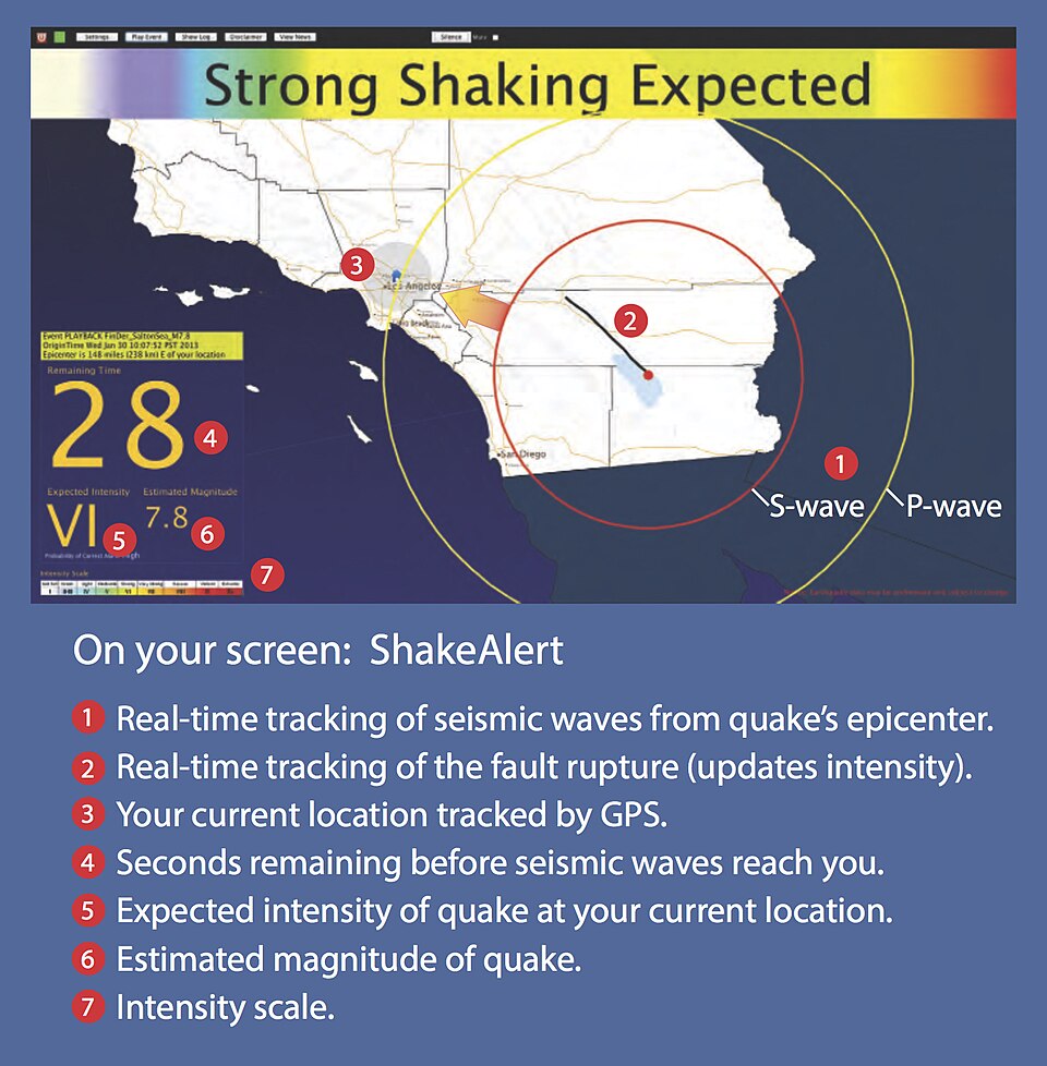
ShakeAlert messages are delivered to devices through Android phones, a limited set of iOS apps, and third-party systems (including mass transit and utilities) so that people and systems can respond to the shaking. A 5-10 second warning is enough to halt a train, open the doors of an elevator, or make a person crawl under a table.
InSAR (Interferometric Synthetic Aperture Radar)
InSAR is a radar imaging satellite technique that measures deformation on the ground with a precision of millimeters. It is applied both pre- and post-earthquake to track land movement, and this enables scientists to know the behavior of faults and seismic hazards.

InSAR is based on the comparison of radar images of the same region at different times. It can track the extent of movement of the ground, even before it produces a quake. Japan and Italy are some of the countries that utilize InSAR to track thousands of faults and volcanic areas in real-time.
MyShake App – Earthquake Alerts on Your Smartphone
MyShake is a mini-seismograph that scientists at UC Berkeley have developed to use your phone. It gathers phone motion data and transmits it to a central system, where it checks whether the motion is in line with an earthquake.

When there is a specific number of users in the same location who are reporting similar shaking, the system can calculate that an earthquake is taking place and send out warnings. The application also provides official alerts in collaboration with ShakeAlert. It is already accessible to Android and iOS users and has been attributed to giving warnings a few seconds before shaking commenced in California and Oregon.
QuakeTech Sensors for Buildings and Bridges
QuakeTech is an enterprise that constructs IoT-enabled seismic sensors that can be mounted on structures such as bridges, tunnels, and high-rise buildings. These sensors capture live data on the structure, vibrations, and patterns that may indicate future stress points.
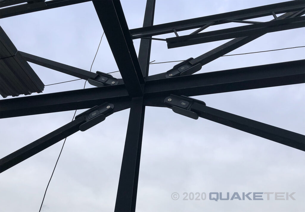
The technology provides immediate damage reports after an earthquake, allowing emergency teams to respond to the most affected areas first. QuakeTech’s analytics software also helps engineers monitor structural wear and tear over time, making cities safer through proactive maintenance
The Most Significant Aspects of the Earthquake Detection Technology
Real-time detection: Sensors are able to detect seismic activity in real time.
Early warning alerts: Early warning systems such as ShakeAlert can give a few seconds of warning before shaking occurs.
Mobile integration: The MyShake app provides seismic alerts into the hands of people.
InSAR allows scientists to obtain a bird’s-eye perspective of the tectonic movement over a period of time.
Infrastructure resilience: IoT devices help engineers to monitor and protect major structures.
Be Ready, Be Informed
Technology is great, but it cannot work unless people employ it. The following are what you can do at this very moment:
- Download MyShake or QuakeAlertUSA.
- Activate alerts on your smartphone in case you are in a risky region.
- Be knowledgeable about your area’s fault lines and risk levels.
- Secure heavy furniture on the floor in your house or office and make an earthquake safety plan.
- Fund public spending on seismic detection and early warning systems.
The devastating effects of earthquakes can be reduced with the help of smart technology and proactive preparation, even though we cannot prevent them.
The Future Is in Smart Detection, Not Prediction
Although we are yet to be very near in predicting the time and location of the next big earthquake, the future of earthquake monitoring has already arrived, and it is a combination of seismic sensors, satellite data, AI, and mobile connectivity. Such technologies are saving lives, infrastructure, and giving people the precious time to act.
There is even more in the future: more accurate warnings, more international sensor networks, and more friendly tools at the individual level. The Earth is always liable to shake, but now, with technology, we do not have to be caught unawares.